Scaling Geospatial Pipelines: From 10 Files to 10,000 in AWS Batch
The production lessons behind moving an imagery workflow from local scripts to an observable, permission-safe, highly parallel cloud pipeline.

Scaling a geospatial pipeline is rarely only a coding problem. It is an infrastructure problem involving memory, identity, concurrency, observability, and cost. When transitioning from processing local geotiffs on a workstation to handling tens of thousands of satellite tiles on AWS Batch, standard batch setups fail in subtle ways.
Here is the behind-the-scenes architecture and hard-won production lessons we use at Infryne TechWorks to turn fragile geospatial scripts into resilient, high-throughput cloud processing systems.
Treat "Essential Container Exited" as a Starting Point
Our first AWS Batch runs failed with the unhelpfully broad Essential container in task exited message. The useful signal lived one layer deeper in the exit code and container reason. AWS documents how non-zero exit codes and the /aws/batch/job log group surface failed attempts in its job-state reference.
Kernel Killed the Process
Raster operations can expand compressed imagery into massive in-memory numpy arrays. If the job reaches its container memory limit, Linux kills it instantly. Profile representative tiles before arbitrarily raising job definition memory.
Unbuffered Log Drops
Python standard output is buffered by default in non-interactive shells. If a crash occurs before buffers flush to CloudWatch, the task appears silently dead.
We force Python logs to stream unbuffered from the container:
# Dockerfile
ENV PYTHONUNBUFFERED=1

# Or runtime entrypoint
CMD ["python", "-u", "process_tile.py"]Always log the S3 tile key, array index, allocated memory, and processing stage before loading raster data. A crash should immediately identify the unit of work without running expensive forensic reruns.
Separate Platform Identity from Workload Identity
A headless container running in AWS Batch does not inherit workstation credentials. Our initial NoCredentialsError was resolved once we cleanly separated the container execution role from the application job role.
- Pulls container image from Amazon ECR
- Writes container stdout/stderr to CloudWatch
- Fetches SSM/Secrets Manager environment variables
- Reads specific S3 imagery input prefixes
- Writes processed COGs to S3 output buckets
- Restricted by strict least-privilege IAM policies
AWS details this exact architecture in its documentation: the execution role is used by the ECS container agent, while the job role is assumed by the Python script. Review the AWS IAM role guide.
Coordinate 10,000 Independent Tiles with Array Jobs
Rather than managing 10,000 individual job submissions, AWS Batch provides array jobs. Every child container receives an AWS_BATCH_JOB_ARRAY_INDEX environment variable that maps cleanly to a pre-validated manifest.
aws batch submit-job \
  --job-name satellite-imagery-batch \
  --job-queue geospatial-high-throughput \
  --job-definition imagery-processor:14 \
  --array-properties size=10000
AWS Batch supports array sizes from 2 up to 10,000 child jobs. The parent job acts as a single lifecycle handle while each child task executes independently with its own retries and log stream. See the official array-job behavior.
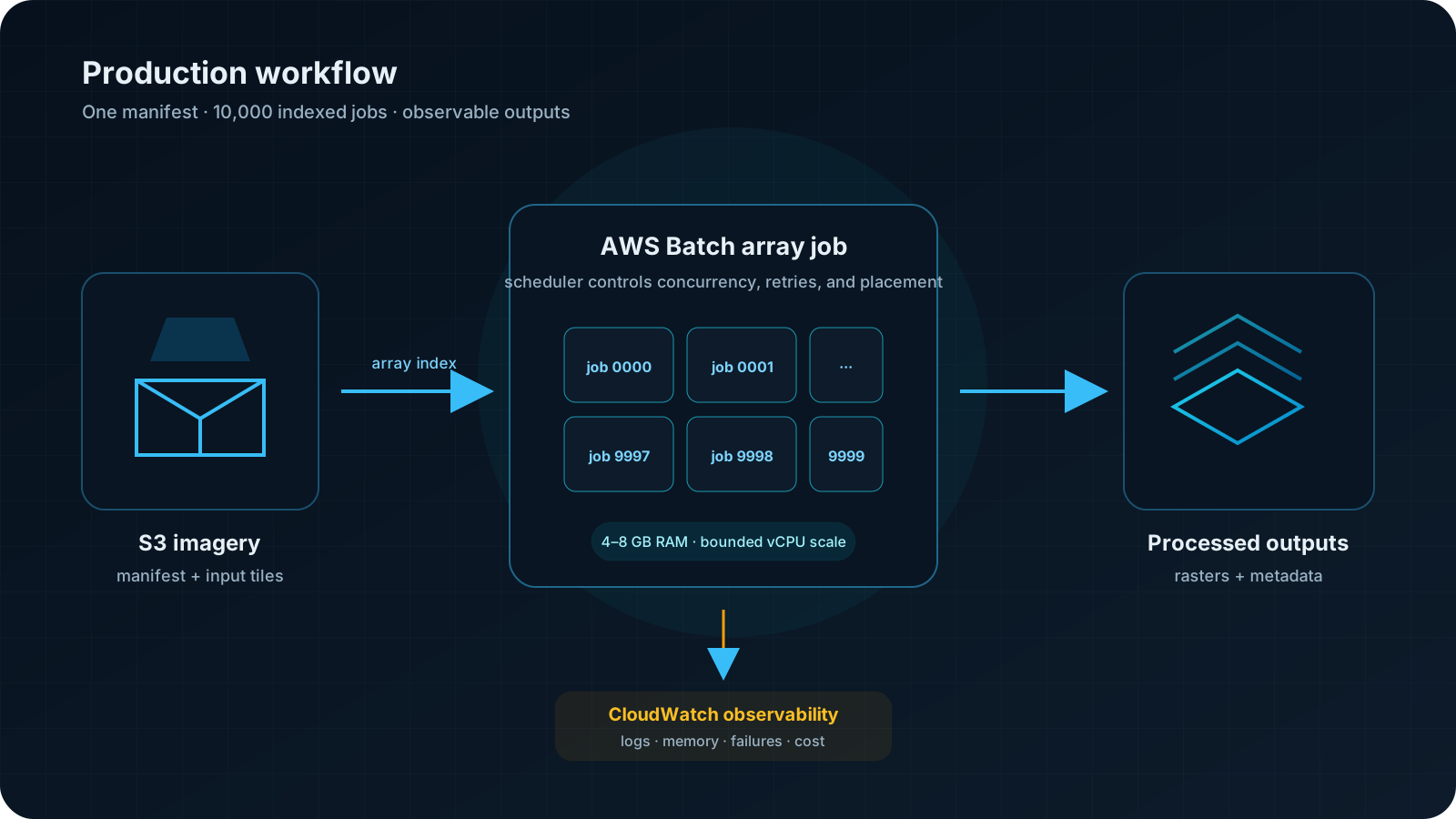
Scale Compute Deliberately and Smooth S3 Concurrency
Submitting 10,000 tasks simultaneously can overwhelm downstream S3 prefixes with burst requests, resulting in HTTP 503 SlowDown responses. Adding bounded jitter to startup routines smooths the initial request crest.
import os, random, time

index = int(os.environ["AWS_BATCH_JOB_ARRAY_INDEX"])
# Prevent 10,000 workers from hitting S3 on the exact same second
time.sleep(random.uniform(0, 120))
process_tile(manifest[index])
Amazon S3 scales automatically to virtually any request volume, but the partition scaling curve is gradual. Read the current S3 performance guidance.
Make Geospatial Functions Explicit and Testable
Positional arguments in Rasterio functions like rasterize() can cause silent bugs across dependency updates. We enforce explicit keyword arguments and strict type validation in all worker routines.
from rasterio.features import rasterize

mask = rasterize(
    shapes=geometries,
    out_shape=(height, width),
    transform=affine_transform,
    fill=0,
    default_value=1,
    dtype="uint8",
)
Compare and verify the parameter signatures against Rasterio's official rasterize() API reference.
The Final Production Workflow
| Stage | Action | Outcome |
|---|---|---|
| Debug | Forced unbuffered stdout logs | Isolated missing dependency and corrected Docker context. |
| Permissions | Assigned execution vs job IAM roles | Resolved S3 auth with zero credential leaks. |
| Logic | Explicit keyword arguments in Rasterio | Deterministic mask generation across tile bounds. |
| Scale | Controlled vCPU quotas & S3 jitter | Sustained concurrency with predictable costs. |
| Operate | Granular per-tile CloudWatch alarms | Full observability and automated single-tile retries. |
Planning a Large Cloud Run?
Design the Failure Path Before the Scale Test
We help teams turn fragile geospatial scripts into observable cloud pipelines with clear resource, security, and cost boundaries.